Back Pamir Afrikaans جبال بامير Arabic Pamir dağları Azerbaijani Памир Bashkir Памір Byelorussian Памір (горная сыстэма) BE-X-OLD Памир Bulgarian পামির পর্বতমালা Bengali/Bangla Pamir Breton Pamirske planine BS
| Pamir Mountains | |
|---|---|
 Pamir Mountains | |
| Pinakahalangkaw na Piye | |
| Rukrok | Kongur Tagh |
| Elebasyon | 7,649 m (25,095 ft) 7,649 metre |
| Tagboan | 38°35′39″N 75°18′48″E / 38.59417°N 75.31333°E |
| Mga dimensyon | |
| Pagpapangaran | |
| Heograpiya | |
| Nasyon | Tajikistan, Kyrgyzstan, Pakistan, Afghanistan and China |
| Rehiyon | Gorno-Badakhshan, Osh Region, Wakhan, Chitral & Gilgit Baltistan, Pakistan and Xinjiang |
| Saklaw nin Tagboan | 38°30′N 73°30′E / 38.5°N 73.5°ETagboan: 38°30′N 73°30′E / 38.5°N 73.5°E |
| Heolohiya | |
| Pagtukad | |
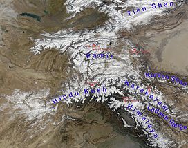
An Kabukidan kan Pamir iyo an sarong kabukidan sa pag-ultanan kan Central Asia asin Pakistan. Namomogtak iyan sa junction kaiba an ibang notableng mga kabukidan, na an mga ngaran iyo an mga kabukidan kan Tian Shan, Karakoram, Kunlun, Hindu Kush asin an Himalaya. Sinda iyo an nagkapira sa pinakahalangkaw na bukid sa kinaban.
Kadaklan sa Kabukidan kan Pamir namomogtak sa Gorno-Badakhshan Province kan Tajikistan.[1]
- ↑ According to the Big Soviet Encyclopedia "The question of the natural boundaries of Pamir is debatable. Normally Pamir is regarded as covering the territory from Trans-Alay Range to the north, Sarykol Range to the east, Lake Zorkul, Pamir River, and the upper reaches of Panj River to the south, and the meridional section of the Panj valley to the west; to the north-west Pamir includes the eastern parts of Peter the Great and Darvaz ranges."
